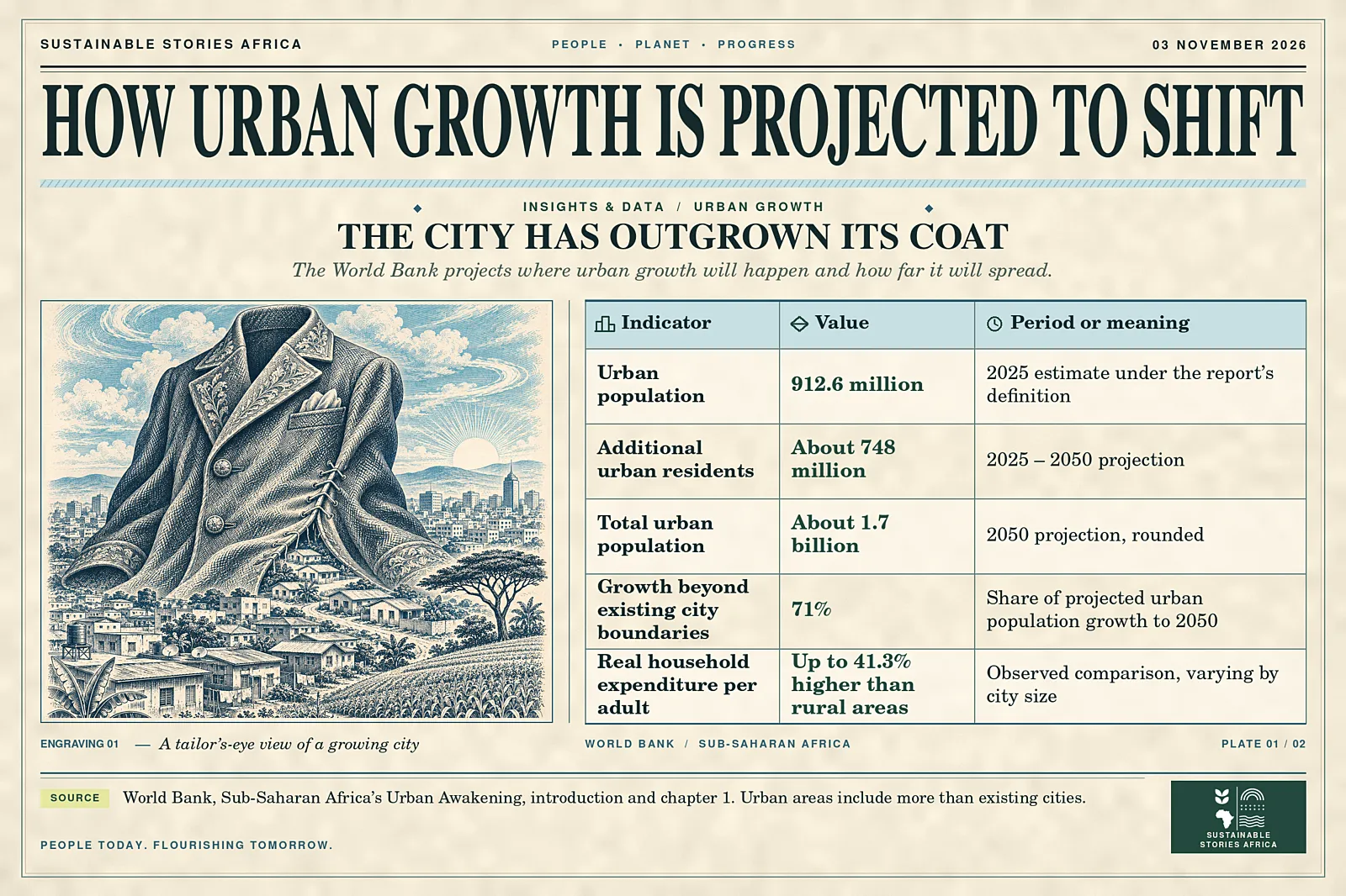
The World Bank projects that sub-Saharan Africa will add about 748 million urban residents between 2025 and 2050, with 71% of that growth beyond today’s city boundaries.
The jobs those residents can reach will depend on decisions about land, transport and basic infrastructure made while urban areas are still taking shape.
Urban Growth Moves Beyond Today’s Cities
Sub-Saharan Africa is projected to add about 748 million urban residents between 2025 and 2050, taking its urban population to roughly 1.7 billion.
The World Bank estimates that 71% of the increase will occur beyond current city boundaries.
- Decisions made now on where to extend roads, water and power will help determine whether those places become connected labour markets.
The Bank’s report, released on 29 October, argues that the region’s cities can support more and better jobs when firms can cluster and workers can reach them.
- Without that connection, more people can live in a metropolitan area while businesses still struggle to recruit and workers spend hours getting to jobs.
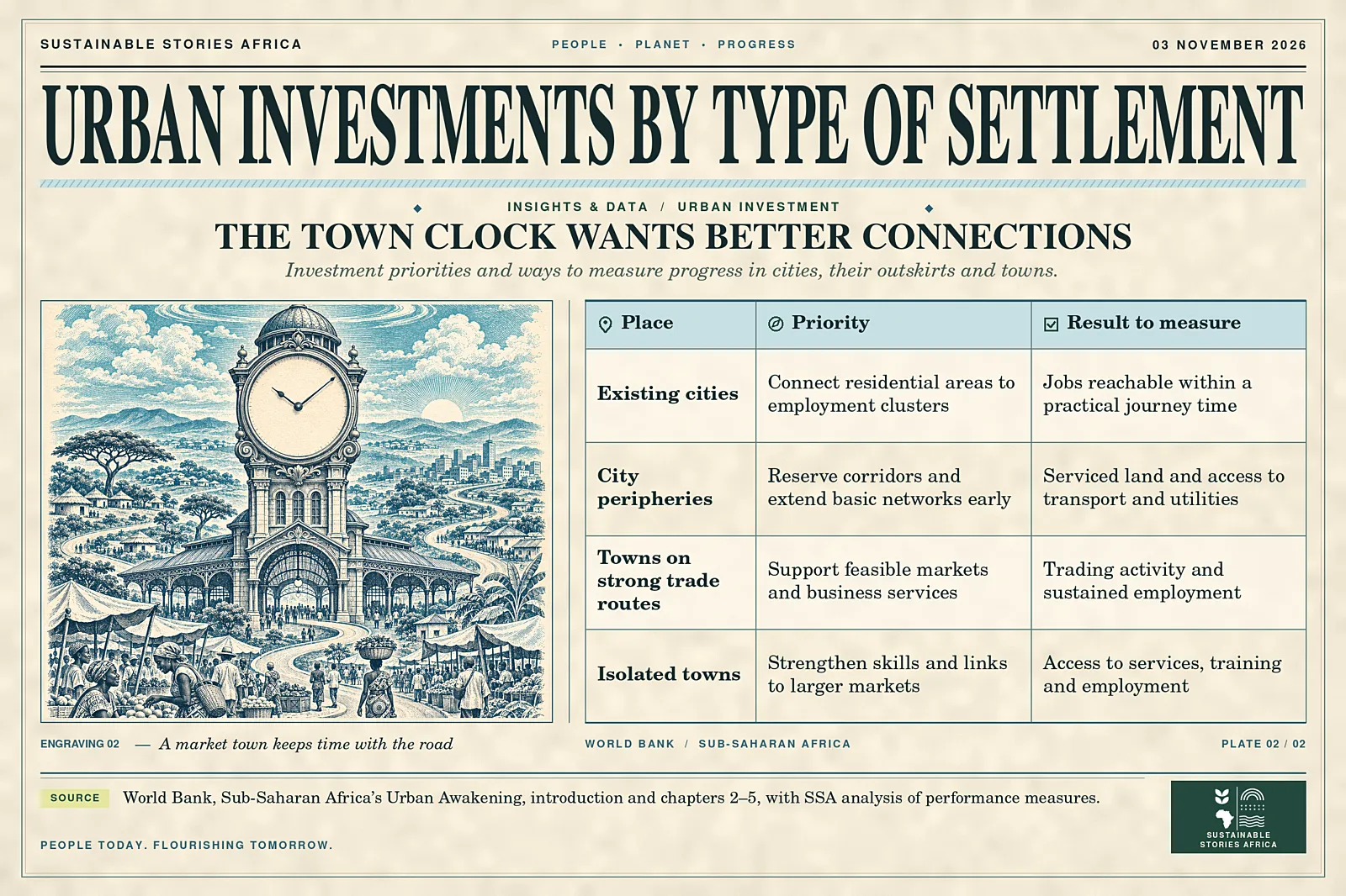
The lesson applies differently to central cities, their expanding fringes and smaller towns.
- Existing centres may need more reliable transport between homes and employment.
- Peripheral areas need land and services laid out before development makes connections expensive.
- Towns need investment that reflects their links to trade routes, farms and larger markets.
Why Population Growth Alone Falls Short
Sub-Saharan Africa added more than 181 million urban residents between 2014 and 2024, the report says, while real regional GDP per person stayed around 4,370 in constant 2021 international dollars at purchasing power parity.
- The regional averages combine different national and local trajectories.
Together they show why a rising urban population is an insufficient measure of economic progress.
- An employer benefits from a large city if its workers and suppliers can reach it.
- A family benefits from a broad labour market if travel costs and time leave the available jobs worth taking.
- Traffic, poor connections and unreliable utilities can limit those gains even where the population is dense.
Depending on city size, real household expenditure per adult can be as much as 41.3% higher than in rural areas.
This compares to observed living standards.
- Individual earnings after a move depend on the person and the work available, and city averages can conceal large differences across neighbourhoods.
The report shows how patterns can vary within one metropolitan area.
- Near a main road, a new settlement can grow around existing transport, while another neighbourhood can fill in away from services or require crossings that are expensive to build later.
- A metropolitan plan can recognise both patterns by mapping job locations, watercourses and expected housing growth together.
This helps authorities distinguish where to add capacity to an existing route from where they need to protect a connection before new buildings close off the option.
Where the Next Urban Residents Will Live
The Bank uses an international settlement classification to compare places consistently.
- This matters because official administrative boundaries vary, and built-up areas and daily commutes can stretch beyond them.
- Under the report’s definitions, the region had 912.6 million urban residents in 2025, including people in cities and other urban settlements.
The largest share of future growth is projected outside current city footprints.
- Some will occur on the edges of major cities and some in smaller settlements.
- A development plan based solely on municipal boundaries can miss the road, drainage or transport connections that residents will need.
Smaller towns have varied prospects.
- A town on a reliable trade corridor may build a market for farm produce, distribution or repair services.
- Where local demand is thin, and connections are weak, education, health and links to larger labour markets may offer more than a costly industrial site.
In Kumasi, Ghana;
- The report cites that congestion cuts the incomes of formal and informal transport operators by an average of 21.9% and reduces productive working time by about 9% a day.
In Nairobi County,
- The report finds that land-use changes could improve access to formal jobs even without new transport investment.
The two cases show why authorities need to look at what holds back access locally.
- In some places congestion slows a useful route.
- In others the problem starts with where homes and jobs are allowed to locate.
What Better Connections Could Do for Jobs
A reliable bus route can expand the number of employers a worker can consider.
A safer connection to the route matters if the trip begins early, ends late or includes dropping children at school.
For a small business, a shorter and more predictable journey to customers or warehouses can free up time and lower the cost of carrying inventory.
Shared infrastructure also helps firms operate near suppliers and services.
- A manufacturing cluster can justify specialised maintenance, training or logistics that would be expensive for a single firm to buy.
These benefits depend on enough firms choosing the location and on reliable power, transport and land access.
Extending basic networks ahead of growth can help avoid more expensive retrofits.
- Reserving space for transport and drainage is easier while development is still sparse.
- Decisions about land must account for existing users, affordability and hazard exposure.
An early plan can allow residents to see where services are coming and participate in decisions that affect how they live and work.
Better access can also raise land values near a station or a serviced industrial area.
- If rising rents push workers further away, some gains in travel time may be lost.
- Municipalities can include housing costs and the needs of existing residents in their assessment of a transport project.
They can also track changes in fares and total journey time after a route opens.
- A project that looks efficient when measured in kilometres built may offer little to households that cannot afford the fare or reach the station safely.
Who Can Plan Across City Boundaries
National governments can give neighbouring authorities the mandate and resources to plan shared infrastructure.
- Municipalities can map where housing and employment are growing and reserve space for connections that cross their borders.
- Transport agencies can measure how many jobs residents can reach within a practical journey time, including waiting and transfers.
Land agencies can clarify rights and streamline permits while protecting people whose land or homes would be affected by development.
- Utilities can publish the order in which they will extend networks and what funding is available for maintenance.
- Aligning those schedules can prevent a road opening long before electricity or drainage arrives.
Investment plans should match each place.
- A city can prioritise links between existing workers and firms.
- A growing fringe may need trunk infrastructure and a way to govern across municipal lines.
- A town can focus on a real commercial advantage or strengthen services and routes residents already use.
Path Forward – What to Measure as Cities Grow
Governments can bring land, transport and investment decisions together around where people live and work.
They should report travel times, service reliability and access to employment as new districts take shape.
The next 25 years will add residents at a pace that makes early choices consequential. Investments can make that growth easier for workers and firms to use.