Flood maps often indicate where water may accumulate. They do not always reveal whose homes, livelihoods or access to essential services are most threatened.
A 2026 Hamburg study combines rainfall hazard, exposure and socioeconomic vulnerability to identify more meaningful urban risk hotspots.
Its approach could inform African flood-resilience planning, provided local data and conditions are independently modelled rather than copied from Germany.
Rainfall Alone Cannot Explain Urban Flood Harm
Two streets may experience the same heavy rainfall and have very different outcomes
- In one neighbourhood, residents can reach higher ground, replace damaged property and access alternative transport.
- In another, an impassable road may prevent people from reaching work, schools or emergency care while vulnerable households lack resources to recover.
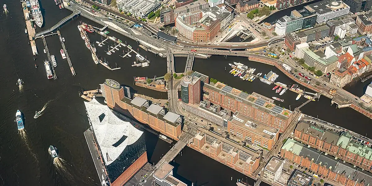
A research team led by Malte von Szombathely developed a high-resolution approach to urban pluvial flood risk in Hamburg, Germany.
- The study was accepted on 5 October 2026 and made available as a journal pre-proof ahead of final typesetting.
- It integrates the hazard posed by intense rainfall with exposure and social vulnerability, following the IPCC risk framework.
African cities facing rapid urbanisation, drainage pressure and climate extremes can draw methodological lessons from this work.
The Hamburg results are not direct measurements of flood danger in Lagos, Accra, Nairobi or any other African city.
Real Flood Risk Goes Beyond Water Depth
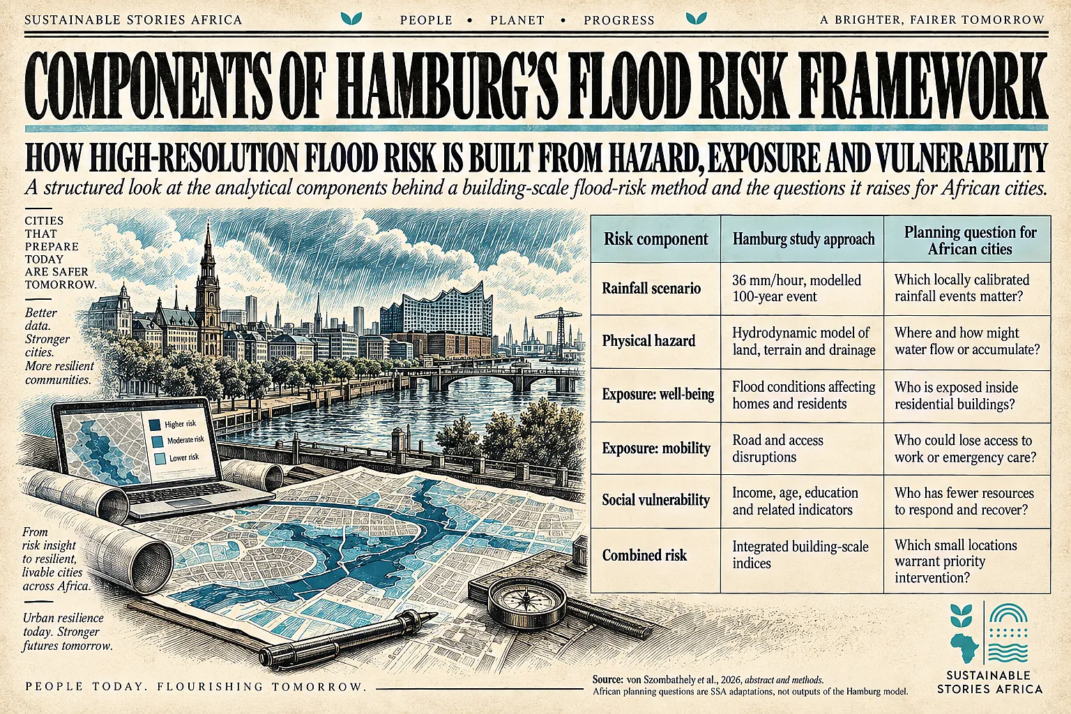
The study models a 100-year rainfall event of 36 millimetres per hour using hydrodynamic simulation that incorporates topography, drainage capacity and land use.
- The title “100-year event” describes an estimated annual exceedance probability of about 1% under the relevant assumptions.
- It does not mean that such rainfall can occur only once every century.
Researchers distinguish two outcome dimensions:
- Risk to mobility and accessibility
- Risk to well-being.
They then combine hazard and exposure with socioeconomic indicators such as age, income and education.
- This matters because flood protection cannot rely solely on maps of the deepest water.
- Homes, road access and people's ability to cope may create very different risks within small areas.
The research reports weak, statistically non-significant spatial relationships between its social-vulnerability measure and the two hazard measures.
- Thus, places with higher physical flood hazard were not necessarily the same places with the highest social vulnerability.
- A city that directs all spending to the most visibly waterlogged locations could miss communities facing serious compounded harm.
Neighbourhood Level Detail Reveals Compounded Disadvantage
The Hamburg study identifies areas where risks to well-being and mobility overlap, including Eppendorf, Billstedt, Övelgönne, Wilhelmsburg and Neugraben.
- It also highlights places where mobility-related concerns are more prominent, including Jenfeld and Osdorfer Born.
- These names refer only to Hamburg.
- Their importance is methodological: risks can change markedly over short distances and depend on more than elevation.
The study finds a statistically significant but modest spatial association between the two combined risk indices (Lee’s L = 0.1032, p < 0.01).
- More tellingly, the reported relationships between its social-vulnerability index and the respective physical hazard measures are close to zero and not significant (Lee’s L = −0.0020 and 0.0022, with p-values 0.536 and 0.396).
The implication is not that inequality and flooding are unrelated.
- Rather, the distributions of flood hazard and social disadvantage must not be assumed to overlap neatly.
Their interaction must be mapped.
- A district might have modest average water depth but contain vulnerable residents near roads that become impassable.
- Another may face substantial building exposure where households have stronger coping resources.
For African municipalities, the transfer challenge is substantial.
- Fine-scale rainfall, drainage, elevation, building occupancy and socioeconomic datasets may be incomplete or held by different agencies.
- Informal settlements can change quickly.
Blocked drains, land reclamation, coastal surge, river overflow and inadequate solid-waste systems influence flood patterns.
- These are mechanisms that require local modelling beyond the Hamburg pluvial scenario.
Better Maps Support Fairer Adaptation Investment
Risk-sensitive urban planning can guide interventions that protect both infrastructure and vulnerable people.
- Prioritise drainage upgrades where they protect homes and critical routes.
- Public transport contingency planning can support access to hospitals and work.
- Social protection measures can reduce recovery burdens for households with limited capacity to absorb a flood-related income shock.
A high-resolution approach can also improve climate-finance proposals.
- Rather than requesting resources for broad districts without a clear theory of impact, municipalities could show the number and type of exposed assets, the communities served, and the changes in risk that proposed investments should produce.
Disclosing the methods and underlying datasets for such metrics can support accountability.
Care is needed to protect residents’ privacy.
- Mapping vulnerability at an individual-building scale can inadvertently identify sensitive household characteristics.
- Public reports should therefore aggregate or anonymise information appropriately and involve communities in validating proposed interventions.
- Scientific precision in a model is not a substitute for local knowledge of past flooding or informal access routes.
Build Local Risk Maps With Communities
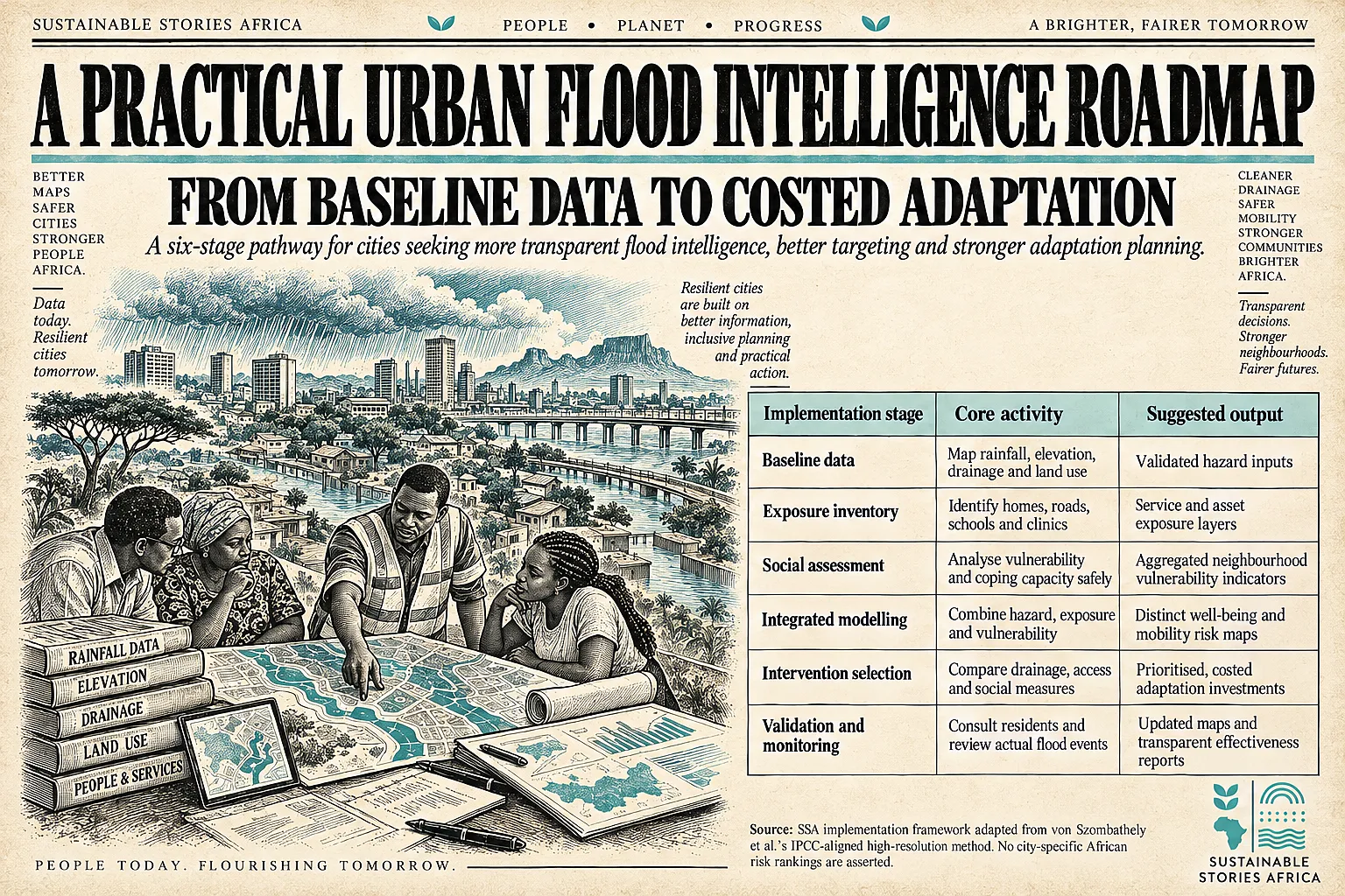
African city authorities can begin with pilot catchments that combine elevation, drainage and land-use data with locally validated vulnerability indicators.
- They should distinguish pluvial, river and coastal hazards; calibrate rainfall assumptions to local climatology; and test data quality before ranking neighbourhoods.
- Emergency managers, health services, transport agencies and residents should participate in selecting relevant outcomes.
Model limitations must accompany every map:
- Uncertainty in rainfall intensity, drainage networks, surface geometry and household data can materially affect predicted hotspots.
- Research results can inform adaptation decisions, but final engineering should include field verification, safe access planning and ongoing monitoring rather than relying on a single simulation.
Path Forward – Protect People Not Just Floodplains Alone
The Hamburg research shows why urban flood planning must integrate rainfall hazards with mobility, building exposure and social vulnerability.
African cities could adapt this approach to spend limited resilience funds more fairly.
The priority is to build trustworthy local datasets, validate them with communities and translate risk maps into drainage, accessibility and social protection measures that reduce real losses.