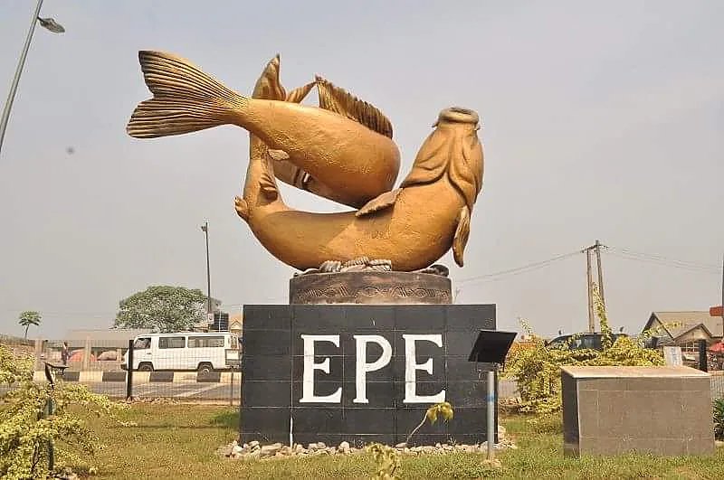
A study of Epe Town in Lagos State shows how climate change is reshaping urban planning, from drainage and infrastructure design to public health and livelihoods.
The findings point to a practical lesson for African cities: resilience cannot be treated as an emergency response.
It must be built into land-use, infrastructure, sanitation, housing and green space planning.
Climate Pressure Is Rewriting Urban Planning
Epe Town, a coastal settlement in Lagos State, is facing a planning challenge that many African cities now recognise. Climate change is no longer a future scenario, but a present pressure on drainage, roads, housing, livelihoods and public health.
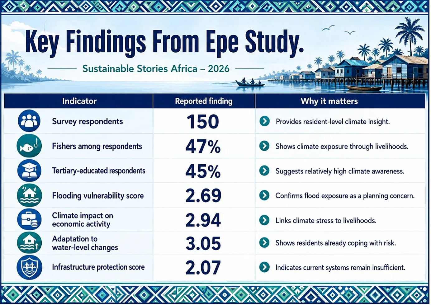
A May 2026 study by Sesan John Adams in the Mediterranean Journal of Social Sciences examined Epe’s vulnerability and resilience to climate change, using 150 questionnaires administered to residents in vulnerable areas.
The study focused on how climate impacts affect urban planning and what adaptation measures are emerging.
Its central finding is clear. Epe has begun adapting through flood-resistant infrastructure and climate-resilient zoning; however, major gaps remain, particularly in green-space capacity infrastructure for integration.
For Lagos and other fast-growing African cities, the message is urgent: the quality of urban planning will increasingly determine who is protected from climate shocks, and who is left exposed.
Coastal Cities Face Planning Stress
Epe’s climate story begins with geography. The town is located in Lagos State on the northern side of the Lekki Lagoon, surrounded by bodies of water, such as the lagoon and the Atlantic Ocean.
Its economy is strongly linked to fishing, agriculture and commerce, making climate disruption both an environmental and livelihood issue.
The study cites Epe’s 2006 census population of 181,409 and a 2022 projection of about 269,000 people.
That location gives Epe economic value and increases exposure. Flooding, coastal erosion, saltwater intrusion and water-level changes are not abstract hazards for residents.
They affect roads, homes, drainage systems, markets, fishing activity, farming patterns and sanitation.
The map on page 3 of the study places Epe within Lagos State and identifies the study area, underscoring why its positioning around water makes urban planning more complex.
In such settings, drainage design, land-use control and infrastructure standards become climate-risk tools, not just planning paperwork.
The research found that Epe residents reported vulnerability to flooding, with a mean score of 2.69, just above the study’s vulnerability threshold of 2.68.
Climate change’s effect on economic activities scored higher at 2.94, while adaptation to changes in water-body levels scored 3.05, suggesting that residents have developed coping strategies from repeated exposure.
Data Shows Planning Priorities Clearly
Research from Epe highlights how Lagos State is converting climate change concerns into measurable planning signals, using a Likert-scale methodology to assess vulnerability, urban planning effects and adaptation priorities.
Values above the general mean of 2.80 were treated as significant, separating perceived priorities from lower-ranked planning concerns.
Three findings stand out. Flooding has become a core urban design problem.
Increased flooding affects drainage planning and infrastructure design, with a score of 2.84, meaning drainage systems can no longer be designed around historical rainfall assumptions alone.
For residents, this translates into waterlogged streets, disrupted transport, damaged property and rising post-rainfall household costs.
Infrastructure resilience is increasingly non-negotiable.
Damage requiring resilient construction and maintenance planning scored 2.82, pointing to practical needs, flood-resistant roads, safer facility siting, maintained drainage channels and building standards that reflect current climate realities.
Public health has also entered the urban planning conversation.
Waterborne disease risk recorded the highest urban-planning effect with a score of 2.93, confirming that climate-linked flooding is simultaneously an engineering, sanitation and health-planning challenge.
The study also exposes a revealing blind spot. Loss of livelihoods due to waterlogging scored 2.62, falling below the accepted threshold, suggesting that economic disruption remains underweighted in formal planning despite its direct impact on residents.
Resilient Planning Can Protect Lives
The opportunity for Epe, and other similar African coastal towns, is to turn climate risk into a planning reform agenda.
Better drainage planning can reduce flood damage. Stronger construction standards can protect public infrastructure.
- Climate-resilient zoning can reduce settlement in high-risk areas.
- Green spaces, wetlands and parks can absorb stormwater, reduce heat and improve liveability.
- Health-sensitive planning can reduce waterborne disease exposure.
The study shows that some adaptation is already taking place.
- Flood-resistant design in urban infrastructure development scored 2.4, above the adaptation threshold of 2.23.
- Implementation of climate-resilient urban zoning and land-use policies scored 2.39, also above the threshold.
These findings suggest that Epe is not starting from scratch; planning adaptation is already visible.
However, the weak point is green infrastructure. Integration of green spaces to mitigate climate impacts scored only 1.9, below the accepted threshold.
That matters because green spaces are not decorative extras in climate-stressed towns. They can function as flood buffers, heat reducers, air-quality assets and public-health infrastructure.
- For citizens, this is the difference between a city that floods and recovers slowly and a city that absorbs climate shocks with less damage.
- For investors, resilient planning reduces asset risk.
- For the government, it lowers future disaster spending.
- For communities, it protects homes, incomes and mobility.
Cities Must Shift From Reaction
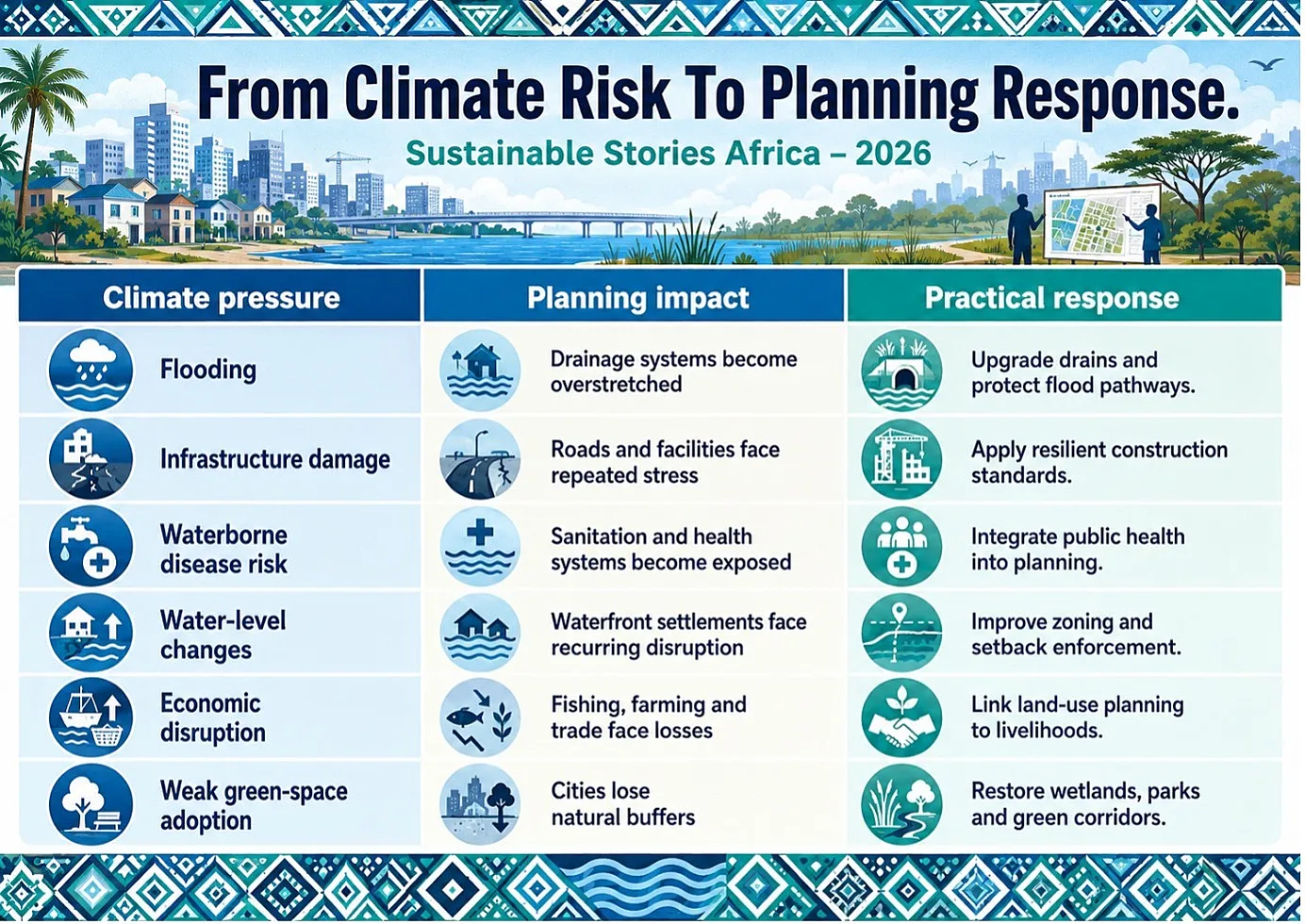
Epe’s findings point to five practical actions for city authorities, planners, financiers and communities.
- First, climate risk must be embedded in land-use planning. Coastal towns need zoning rules that discourage development in high-risk flood zones, protect natural drainage corridors and require climate-sensitive layouts for new settlements.
- Second, infrastructure standards should be updated. Roads, bridges, markets, schools, clinics, and drainage systems must be designed for heavier rainfall, flood recurrence and higher maintenance demands. The study’s findings highlight that the current infrastructure protection score is only 2.07. This is a warning that existing systems are not enough.
- Third, green infrastructure must be treated as core urban infrastructure. Wetlands, parks, green roofs, tree cover and restored waterways can reduce flood intensity and heat stress. The low green-space score in Epe suggests a missed opportunity that planners can still correct.
- Fourth, sanitation and health planning must be integrated with climate adaptation. Since waterborne disease risk emerged as the strongest planning concern, drainage, waste management, access to clean water, and local health systems should be planned together.
- Fifth, livelihoods must be brought into resilience planning. Epe’s economy depends heavily on fishing, agriculture and commerce. Climate adaptation should therefore include support for fishers, farmers, traders and small businesses affected by flooding, water-level changes and environmental stress.
Path Forward – Plan Cities Around Resilience
Epe’s lesson is direct: African cities must integrate infrastructure, policy and green spaces before climate stress becomes urban breakdown.
The next planning agenda should prioritise flood-resistant design, climate-smart zoning, sanitation protection, livelihood resilience and restored natural buffers.
That is how urban planning advances ESG goals, protects communities and turns climate adaptation into daily development security.