
A review of the water planetary boundary argues that global environmental limits need practical translation into river-basin decisions.
The proposed framework assesses what water systems do for ecosystems and people.
For African basins, the promise is a clearer account of trade-offs.
Applying it will require local data, modelling capacity and participation that gives affected communities a meaningful voice.
Global Water Limits Need Local Decisions
A river basin can meet a water-volume target while failing to support healthy ecosystems or equitable access.
Review and reframing of the operationalisation of the water planetary boundary for river basin planning, by Emilio Politti and colleagues, proposes a framework to address that gap.
A 2026 accepted manuscript for Environmental Research Letters. It reviews earlier approaches and proposes a way to apply planetary-boundary principles through basin-scale socio-ecological functions.
The implications for African and emerging markets concern decisions about competing uses of water.
- Communities, agriculture, industry and ecosystems depend on the same connected system.
- A management framework must assess seasonal availability, quality and ecological function alongside the distribution of benefits.
The paper offers a proposed planning approach, not evidence that it has already improved outcomes in a particular African basin.
A Single Water Limit Misses Functions
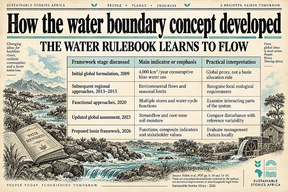
The earliest water planetary-boundary formulation used a global limit of 4,000 cubic kilometres a year for consumptive blue-water use.
- Blue water includes rivers, lakes and groundwater; consumption refers to water not returned to the system.
- The review explains that this metric acted as a proxy for human disturbance rather than a complete operational rule for every basin.
Later approaches introduced environmental flow requirements, seasonal constraints and green water, which concerns moisture supporting land-based processes.
- More recent global assessments use streamflow and root-zone soil moisture against reference variability.
- Each development improves the account of water-system change while raising questions about how global indicators guide local choices.
The central challenge is that one single concept cannot capture all basin conditions.
- A reservoir can support water supply while altering downstream ecological processes. Pollution can compromise a river even when its volume appears adequate.
The proposed framework therefore asks which functions must be maintained, rather than treating water availability as the only objective.
Basin Functions Connect Ecology And Society
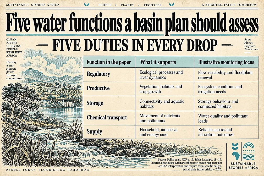
The framework organises blue-water functions into regulatory, productive, storage, chemical-transport and supply roles.
- These functions describe processes ranging from floodplain renewal and aquatic habitats to crop production and domestic water provision.
- They link ecological resilience with activities that sustain human societies.
Each function has a locally defined boundary represented through control and response variables.
- Multiple indicators describe the relevant processes, while a modelling system examines how those indicators respond to alternative allocations, infrastructure and climate conditions.
The hierarchy is intended to remain applicable across basins while allowing lower-level indicators to reflect local circumstances.
- A basin's ecological linkage or water-quality pressures may require particular measures.
- A planner should therefore not assume that an indicator useful in one setting captures the same risk elsewhere.
The review's evidence base also has a defined scope.
- Its systematic search identified 169 records, reduced these to 84 unique records and then selected 36 papers.
- 4 additional important papers were included outside that search.
This review and conceptual proposal is built on a selected literature corpus, rather than a new survey of basin conditions across Africa.
Better Planning Can Make Tradeoffs Visible
The practical benefit is showing how a management decision affects several functions simultaneously.
- Increasing storage might support dry-season supply while changing downstream flows.
- Expanding irrigation may improve production while putting pressure on aquatic habitats or another user's access.
- Making those relationships visible helps institutions discuss the actual choices.
The authors emphasise a safe operating space that also protects social equity.
- Environmental planning should account for current communities, future generations and non-human life.
- A technically efficient allocation can remain unjust if it protects established users while excluding households with less influence or historically limited access.
For an African application, a shared-basin authority could use the framework to compare management options under drought and changing demand.
- This is an illustrative use, not a case demonstrated in the manuscript.
- Effective application would require credible information from participating jurisdictions and a process for considering users whose water needs are poorly documented.
Build Basin Decisions With Shared Evidence
Basin institutions should begin with an agreed account of the functions that need protection and the people who depend on them.
- They can then select indicators that are locally meaningful and sufficiently observable to support decisions.
- The process should explain which assumptions reflect scientific evidence and which reflect choices about acceptable risk or distribution.
The authors recommend multi-criteria decision analysis, particularly multi-attribute value theory, to combine evidence with stakeholder preferences.
- In accessible terms, this compares options against several stated objectives and makes the weighting of those objectives explicit.
- The method can improve transparency, but it cannot remove political conflict or make value judgments scientifically inevitable.
Participation therefore needs safeguards against unequal influence.
- Environmental advocates and disadvantaged communities should be represented, while decision-makers should publish the basis for selected weights and boundaries.
- Essential functions should not disappear inside a favourable overall score: the paper's safe-space concept requires each function to meet its minimum boundary.
The authors identified Data and modelling capacity as major constraints.
- The Global South often has less dense observational coverage, and water-demand information can be incomplete.
- A practical programme should strengthen monitoring and validate model results against field observations before relying on them for consequential allocations.
Governments and financiers can support this capacity as part of water infrastructure investment.
- A dam, irrigation scheme or industrial project should be evaluated within the basin it changes.
- The proposed framework provides a structured way to ask those questions, while its benefits still need testing through real planning applications.
Path Forward – For Fair Basin Management
River-basin planning should protect ecological functions and equitable access.
Local indicators, transparent choices and credible modelling can make competing water uses easier to assess.
African institutions should test the proposed framework in suitable basins while improving monitoring and community participation.
Success will depend on decisions that sustain water-system resilience and essential services, with allocation choices highlighting the limits of data and models.