Four decades of satellite observations show that many drylands are growing greener while their vegetation fluctuates more sharply between years.
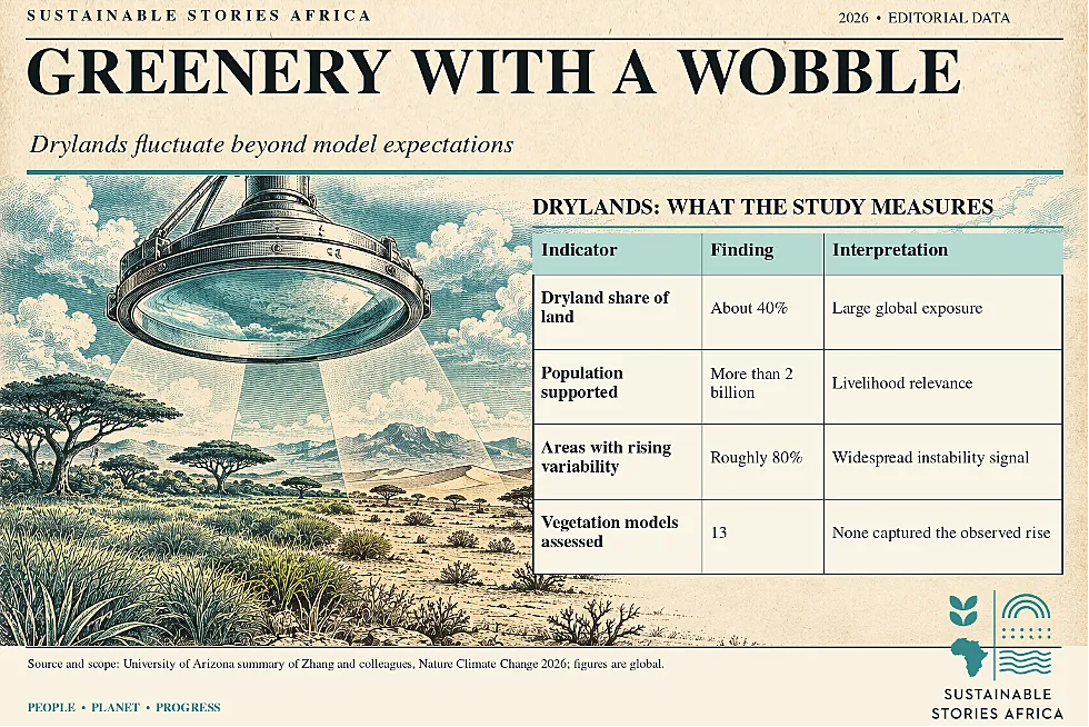
University of Arizona researchers find escalating instability across roughly 80% of global drylands; 13 vegetation models missed the observed increase.
The finding matters for rain-fed farms and pastoral livelihoods that depend on reliable harvests and forage, including across African drylands.
Greener land carries a volatile signal
Drylands can appear healthier in a long-term satellite trend while becoming less dependable from one growing season to the next.
A University of Arizona-led study published in Nature Climate Change finds increasing year-to-year vegetation variability across roughly 80% of global drylands.
The researchers examined around four decades of satellite observations and reported that none of 13 leading vegetation models captured the increase in variability.
This warns climate planning in regions where farming and grazing depend heavily on rainfall.
It does not establish that every green landscape is degrading, or that the same mechanism operates everywhere.
The record reveals boom and bust cycles
Drylands cover about 40% of Earth's land surface and support more than two billion people.
- Satellite measurements of leaf area index, a proxy for plant growth, show a broad greening trend.
However, the higher average conceals larger gaps between strong and weak growing years.
- Researchers suggest that rising carbon dioxide may help plants grow more vigorously during wet years, while later drought leaves larger vegetation structures harder to sustain.
- They say further work is needed to identify the precise mechanisms.
In a rain-fed farming community, this distinction has immediate meaning:
- A good harvest can encourage higher spending on seed, livestock or loans
- A weak following season can quickly erode the gains.
This example illustrates the exposure described by the study; it is not a measured account from any particular African village.
Risk analysis needs more than averages
A greening indicator can be valuable without being sufficient.
- If insurers, land agencies and lenders price land risk from the average amount of vegetation alone, they may miss the range of possible outcomes.
- More frequent or larger swings in forage can complicate grazing decisions; unstable crop growth can challenge repayment schedules and food availability.
The study's model comparison sharpens this concern.
- All 13 assessed models failed to reproduce the observed rise in year to year variability, so their projections may understate an important form of ecological risk.
- The report does not, however, forecast a particular date for a dryland collapse, nor prove that all drylands are approaching one.
Its strongest contribution is showing a mismatch between observed variation and the tools often used to anticipate long-term change.
The finding also complicates common sustainability reporting.
- A company may cite more green cover around a supply chain as evidence of lower environmental risk, even though the year-to-year supply of forage or rain-fed crops is becoming more erratic.
- Longer records and regionally relevant indicators would make that claim more defensible.
- Ecosystem monitoring should distinguish a rising mean from increasing variance and ask whether the worst years are becoming harder to survive.
The research does not quantify financial loss for Africa; therefore, any such estimate would require separate evidence.
It does, however, give agricultural banks and public insurers a way to stress test poor seasons alongside average ones.
- For communities, this could mean investing in water harvesting, seed choices and grazing arrangements that remain useful when a good year is followed by drought.
- Monitoring should also avoid treating satellite signals as a substitute for people’s direct observations of land conditions.
Plan for variation before losses accumulate
African land and agriculture authorities should track both average greenness and changes in variability, pairing satellite observations with rainfall records and local evidence on harvests, pasture and water
- Extension services can help farmers diversify crops and adjust planting decisions; grazing systems need flexible access and timely information during poor seasons.
- Better index insurance would require careful local validation so a remotely sensed signal matches real losses.
Researchers should update ecosystem models and test their performance in specific African drylands, rather than applying a global result as a uniform local forecast.
A greener satellite image should prompt the next question:
- How resilient is that growth when the rains fail?
- Local observations can help researchers distinguish a satellite signal from changes caused by grazing pressure, land management or measurement limits.
This distinction matters when governments decide whether to fund restoration, water infrastructure or farmer support.
- Better monitoring can prevent an apparent improvement in average vegetation from masking recurring livelihood shocks.
Path Forward – Measure Volatility Beyond Greening
The study suggests resilience indicators that capture swings as well as trends.
African institutions can combine satellite data with local harvest, pasture and water records to target support.
Model developers should test drought responses against the observed four-decade record.
Better evidence can improve adaptation plans without treating a global pattern as a prediction for every community.
Culled from: Satellite data expose an escalating 'boom-and-bust' dynamic in greening drylands